Living as I do on the Olympic Peninsula in Washington State, I’ve had the pleasure of walking along many beaches. Each time I visit one, I learn something new, see something new, experience something new. But the thing is, sometimes those lessons and experiences are hidden. They’re not physically hidden from view, or inaccessible in any way. Rather, they’re unavailable because they’re buried in familiarity and repetition. The familiar things become a blur as we search for something new and different. We stop wondering about the commonplace, and in the process, lose track of things that may be important or interesting because we stop asking the question “why?”
This particular story began in early winter on a beach just north of the Kalaloch Campground on the Washington Coast. I have walked this beach, or beaches like it, hundreds of times. This time was different because I stopped, looked, and wondered why.
What I saw was a pile of rocks high up on the beach, just below the vegetation line. The rock pile was not an impressive thing, maybe the size of the living room in your home. But this pile of rocks caught my eye and engaged my brain because it was the only pile around, and all the rocks were uniformly flat and disk-shaped. I have probably walked by rock piles like this countless times in my life, but this one time something clicked. And I asked myself three questions:
- Where did they come from?
- Why are they all round and flat?
- Why are they on this particular beach?
Here’s what I was looking at:
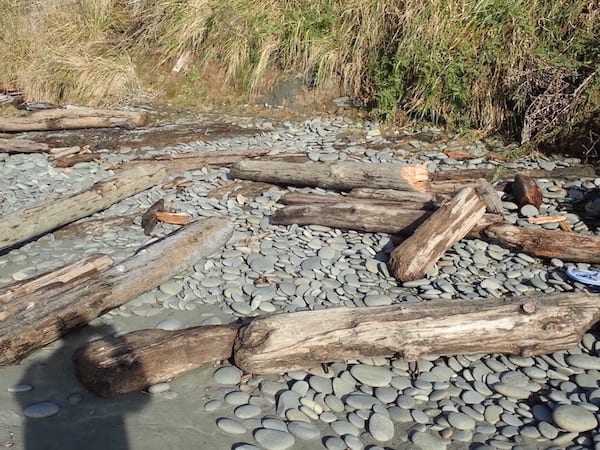
You’ll notice in the photo that these rocks are located high on the beach, way up at the high tide line amongst large driftwood thrown there by big storms. The surrounding beach is mostly sand, gently sloping down to the water. They aren’t everywhere, just in certain places, at least on this particular beach.
I stood there, looking around, pondering the three questions. I initially thought the rocks came from an area in the surrounding slopes and hills, maybe washed downhill by small creeks or eroded by big storms. But poking around above high tide line, I saw mostly clay and peat material. No visible rocks. And even if they did come from an upland source, why were they collected in this one place, and why were they so alike? Maybe the nearby Hoh River carried them there, but how and when?
And then I thought, maybe I should be thinking about this in terms of geological time and try to envision all the things that went on thousands, hundreds of thousands, or even millions of years ago that helped create this pile of rocks. But this gave me a headache, so I wandered back to the car for the long drive home. But I didn’t forget about the rocks. It bothered me a lot that I couldn’t come up with a reasonable explanation for what I had seen, and it bothered me even more that I had walked past rock piles like this for years and never once thought about how they got there.
First Steps
After I returned home, I reached out to my scientifically-inclined friends for answers. A few were familiar with the rock piles but hadn’t really thought about why they were there. I also talked to my coastal geologist friends who gave me some general ideas about what was going on, and tossed out a few hypotheses to consider. Their ideas increased my interest in the subject but didn’t completely answer my three questions. Another friend sent me a link to a technical bulletin written in 1973 by Weldon W. Rau, a geologist working for the Washington State Department of Natural Resources. This document set me on the road to understanding and lead me to what is probably a reasonable answer to my questions. I also learned we can never be sure of the past.
Geology of the Washington Coast Between Point Grenville and the Hoh River is a wonderful source of information, but a bit of a challenging read to the non-geologically inclined. It describes a coastline that is both ancient and recent and ever-changing–a place where the beach features we see today were once a part of the ocean bottom, where tectonic forces, glaciers, rivers, and small streams move an extraordinary amount of material around, and somehow, within and during that process, we end up with flat rocks at Kalaloch called beach shingles.
What I learned from the author of Geology and the other information sources I consulted was that before I could answer my beach shingle questions, I needed to understand the fundamentals of how the coast was formed, and how it continues to change. In other words, I really did need to think about in terms of thousands and millions of years. And the key was learning about three things: subduction, glaciation, and erosion.
Subduction, Glaciation, and Erosion
Subduction explains how the beach I was standing on was once the bottom of the ocean. Millions of year ago, the ocean bottom was an incredibly active place. Runoff from the land was depositing sediment and rocks in offshore deep-water locations, while underwater volcanos were releasing magma, which cooled and covered the land runoff. This continued for millions of years, building layer upon layer of material on what we now call the Juan de Fuca plate. For a while, this plate was relatively stable and not moving around too much. Then, about 30 to 50 million years ago, it began moving east, colliding with the Continental Plate to the east, and moving beneath it. As it moved, the upper Juan de Fuca material was literally scraped off, and became the beach I was standing on (and the Olympic Mountains). I’m still in awe of the forces capable of creating mountains nearly 8,000 feet high from building material located 1000 feet below the ocean and miles from land, but it happened in the distant past. Over time, glaciation and erosion sculpted the new land and moved pieces of it around. And it’s still happening, but it’s not nearly so dramatic now.
The Three Questions Revisited
The most likely answer to the “where did they come from?” question is that the sandstone rocks that became my beach shingles started out as a part of the ancient ocean bottom, and were moved east to create new beaches and coastal mountains. And they were gradually delivered back to the shore by the actions of glaciers, rivers, and streams. This process started millions of years ago and continues to this day.
The “why are they flat?” question is related to how ocean waves and sandstone rocks interact. Ocean waves are really good at sculpting those kinds of rocks, and the rocks often end up as flattened disks, just like the ones I was seeing. During storm events, especially during high tides, those flat rocks can be thrown high up on the beach. And because they are flat, they don’t roll back down. Think about what happens when you kick a Frisbee in the grass and you get the idea.
The “why are they there?” question is a bit harder to answer, no matter how much studying you do or how many degrees you have. Probably the best answer is that some places receive more rocks via erosion than other places, and if the wave action is right, the sculpting occurs more efficiently there than at other places. During big storm events, there are places where rocks collect–kind of like the places on beaches where driftwood piles up during winter storms or we find the most discarded plastic bottles and other marine debris. It’s not necessarily random, but it’s hard to predict, even for professionals, because the processes are complex. But if everything falls into place, there are rock piles like mine just waiting to be discovered.
The Big Picture
If you are lucky enough to walk the beaches near Kalaloch, or some of the other beaches along the Washington Coast, what you will see is the result of millions of years of movement, upheaval, and redistribution. Big events like subduction and glaciation played an enormous part, and the results are still evident to this day. If some of the beach formations you encounter look like they are upside down or standing on end, they probably are, because the scraping action buckled and fractured the material as it moved east and created the complex and interesting beach formations we see today. Beginning about two million years ago and ending roughly 10,000 years ago, glacial ice sheets thousands of feet thick also sculpted the region, moving rocks and gravel and sediment from one place to another. Rivers and streams did their part, delivering rocks to the ocean to be sculpted and tossed around, maybe to delight and confuse the humans encountering them.
And if you personally encounter a bunch of flat rocks huddled together high on a beach, you will experience your very own case of beach shingles.
Information Sources
Dana Hunter, Shingle Beaches: Pebble Paradises. Scientific American Blog. July 30, 2017
Dungeness River Center, Geology of the Olympic Peninsula
Jennifer Ott, Vashon glacier begins to melt and recede from Puget Sound region and Columbia Basin around 16,900 years ago. HistoryLink.org. September 24, 2012
Scraping Together Mount Olympus: Nick of the Rocks. National Public Broadcasting System
Washington State Department of Natural Resources. Olympic Mountains
Weldon W. Rau. Geology of the Washington Coast Between Point Grenville and the Hoh River. Washington Department of Natural Resources, Geology and Earth Resources Division, Bulletin No. 66. 1973
World Atlas, What is a Shingle Beach?
0 Comments